Moab’s Mary Jane Canyon a breath-taking hike of ‘epic beauty’
July 26th, 2011 Posted in Arts and LifeStory by D. Whitney Smith
Photos by D. Whitney Smith and Breck Byington
MOAB, Utah—It is no secret that Moab provides a perfect setting for fair weather fun for outdoors enthusiasts of all kinds. Each year thousands of visitors from the United States and abroad flock to southeastern Utah for annual events, sight-seeing, foot and bike races, 4-wheeling, rafting, rock climbing—the list goes on and on.
 It’s not hard to have a good time in the red-rock canyon country. What might be hard is going to Moab during the busiest time of the season and finding solitude. Spend enough time with the locals and you just might learn a secret or two that will afford you a little alone time.
On the north end of town, the Colorado River transects the Moab Valley briefly and then keeps on flowing down to Lake Powell and beyond. Take Moab’s Main Street north to state Route 128, also called River Road, and head northeast along River Road. Between mile markers 18 and 19, you’ll find an unnamed, dusty road on the right hidden among the sagebrush and juniper trees.
If the wind blows sand in your eyes, you might just miss the turn. On some maps, this road will be marked and shown next to the “Richardson Historic Site.” This name is quite fitting, since the vast open expanse you should find yourself in is referred to as Richardson Amphitheater. Just past a few parcels of private property and a healthy stand of cottonwood trees is the perennial Professor Creek—named after one of Moab’s earliest formally-educated settlers, Dr. Sylvester Richardson.
Professor Creek is one of the many flowing bodies of water that run out of the La Sal Mountains as snow melts and distributes itself, with a little help from gravity, to the thirsty desert valley below. Eventually the creek finds its way to the Colorado River, where it even has a rapid named after it. Professor Creek has been known during rainstorms to flood its banks, overrun culverts, and wash up and over River Road, leaving in its path a rich, red streak of soft desert clay.
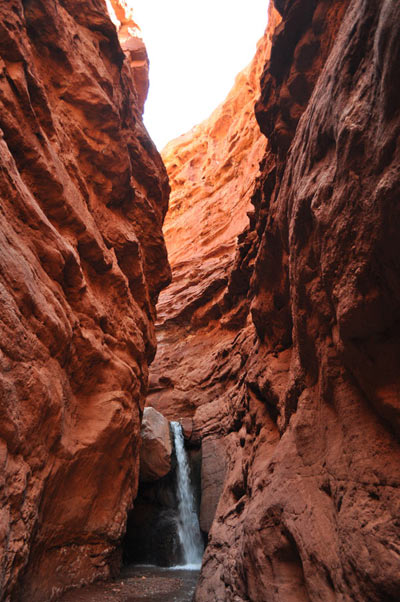
 Just recently, on one of Moab’s busiest weekends of the year, I decided to revisit a special place that a friend showed me five years ago, a place called Mary Jane Canyon—named after Richardson’s wife. Among the things that make Mary Jane Canyon so special are the waterfall hidden deep inside a slot canyon seven miles from River Road, and the chance of seeing anybody other than your hiking buddies is narrower than the canyon itself.
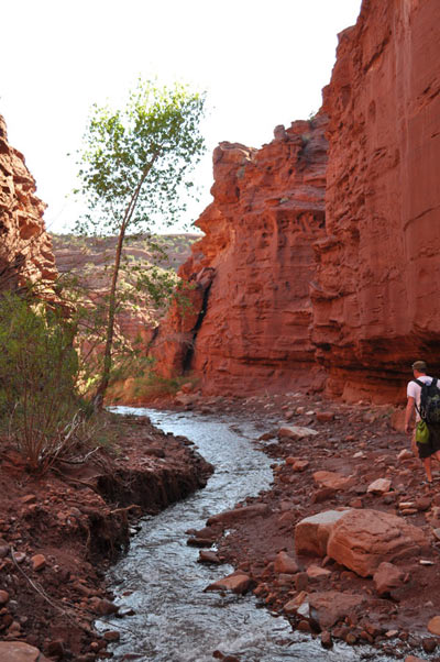
The hike through Mary Jane is so unique because there are no cairns and hardly any footprints or trail markers of any kind. In fact, the “trail” is actually Professor Creek itself. For this trek through the bubbling, tepid stream-bed, I invited recent USU graduate and photographer Breck Byington to join me. As Byington soon found out, taking in the majesty of Mary Jane’s waterfall is not for the faint of heart; even though we began our day late in the morning, we didn’t reach the mouth of the slot until 3 p.m. Of course, we spent time wandering along ridges, taking photographs of rock formations and barrel cacti, all while avoiding cow pies and electrified fences.
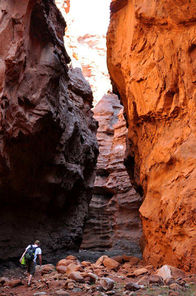
Once inside the otherworldly belly of Mary Jane Canyon’s 50-foot walls, the only practical way out is the way you came. The stream-bed continues to meander back and forth as the walls adjacent to it grow taller, to 100 feet and higher. There were moments as we hiked when the sun was just a memory and, with toes shriveled from walking through water all day, we welcomed its apex in the sky as it shone down on us with reassuring warmth.
 From overhead we could have been spotted from a bird’s-eye view, but on the ground in that canyon, literally nobody could have known where we were. Just moments before I rounded the final corner, I heard the torrents of the rushing waterfall, dropping into a shallow pool of deep-blue water. I turned to look at Byington and yelled to him, “We’re finally there!” When I asked him what he thought of it all, he said, “Epic beauty.”
By the time we made it back to our transport to change our clothes and head back to town, we were sunburned and wiped out. It was just after 8 p.m. We had hiked roughly 14 miles. I encourage experienced hikers to enjoy the beauty of this magical destination. If interested, arm yourself with an adequately-stocked daypack, plenty of water (a quart per hour), a map and somebody with a sense of direction—compasses also tend to work.
This hike is a local secret, which means not too many people know about it, but all of the places mentioned can be found on a map. I recommend “Latitude 40” topographical maps. They are waterproof and tear-resistant, and they are filled with detail and information about traveling in the desert.
For any other questions refer to the Moab Information Center or e-mail me.
Tags: Mary Jane Canyon, Moab, redrock hike

Sorry, comments for this entry are closed at this time.