
Breath-taking: Climbing the world’s steepest mountain range
September 22nd, 2015 Posted in EnvironmentStory & Photos by Chelsea Hunter Tolman
MENDON — Trudging up the dusty trail, Abby Wangsgard began to wonder what she had gotten herself in to. She hoped the view was worth it.
Even as though she’s a Cache Valley native, this was the 22-year-old’s first time climbing the Wellsvilles.
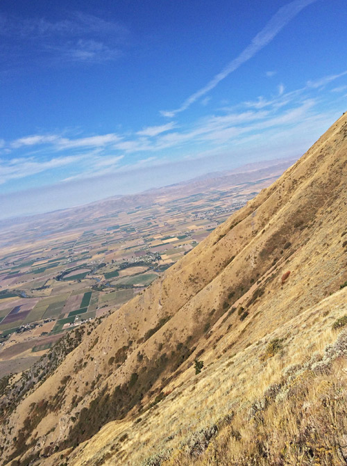
LOOKING SOUTHEAST across Cache Valley, the views are breath-taking.
“I thought I was going to die the whole way up,” Wangsgard said. “The trail wasn’t bad to begin with, but there were parts that were so steep I had to stop like every 10 steps to catch my breath.”
Former USU geology professor Robert Oaks says the Guinness Book of World Records lists the Wellsville Range as the steepest in the world, measured by its height relative to the width of its base.
This means the mountains are very narrow with steep slopes on both sides, which is why they appear to come straight up from the valley floor without significant “benches” or foothills like the other mountain ranges in the area.
The Wellsvilles are steepest, but they aren’t the tallest peaks in Utah — at 9,372 feet elevation, Box Elder Peak is the highest in the range, and ranks 27th among Utah mountains. Mount Naomi, on the east side of the valley in the Bear River Range, is the highest peak in Cache Valley at 9,979 feet, while King’s Peak in Duchesne County is the highest in the state, 13,528 feet.
“You can tell they’re steep just by looking at them,” Wangsgard said. “I just wonder what could have caused them to form like that.”
Oaks says they were formed by geologic faults coming together at once with different forces.
“Between 135 and 55 million years ago, these rocks first were compressed,” Oaks said. “They buckled into broad folds, and were carried from beyond the other side of the Promontory Range on the east-rising Paris-Willard thrust fault, up and over rocks of the same age and later carried eastward piggyback above even younger, deeper thrust faults.”
 Oaks says that after the faults came together, wind and water eroded the tops and sides.
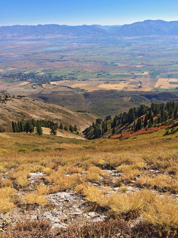
Veteran climbers say their steepness mean the Wellsvilles offer some of the most beautiful views from the top, like standing at the top of a tower.
“Once you get on top, the views are more open,” said 23-year-old Clayton Leuba from Kaysville. “Because it’s such a narrow range, you have a really, really steep look down into Cache Valley on one side and the Brigham area on the other side.”
Leuba is an avid climber, and says the views from the Wellsvilles aren’t like any others.
“If you get up in the Bear River Range and hike up to, say, Mount Naomi or something up Logan canyon, you are surrounded by a lot more mountains and can’t see as far,” Leuba said. “There’s really open views from the top of the Wellsvilles. It’s nice.”
On a clear day from the top of Box Elder Peak, he said, you can see as far as the Uintahs, the Wasatch Range, and up into Idaho.
Hikers can access three trailheads on the Cache Valley side. To the southeast the Rattlesnake trailhead in Sardine Canyon provides the best access to Box Elder Peak (9,372 feet) and Wellsville Cone (9,356 feet). South of Mendon is the Maple Bench trailhead, which provides access to the main ridge at Stewart Pass, Scout Peak (8,687 feet) and Mendon Peak (8,766 feet). At the most northern side of the range (just north of Mendon) is the Deep Canyon trailhead, which provides access to Deep Canyon and the main ridge and Mendon Peak. It is also possible to start at one end of the range and traverse across the whole ridge to the other end.
“You definitely get the experience of being on a very steep mountain,” Leuba said. “But the trail is nice so it doesn’t beat you up too bad. You definitely get the feeling you’re gaining altitude quickly and getting very high up above the valley, for sure.”
Utah’s Summits
Prominence: Mountaineers typically rank peaks not by elevation, but by their prominence, which means the distance climbers have to travel from their base to summit. For example, Box Elder Peak is the tallest in the Wellsvilles at 9,372 feet, but the floor of Cache Valley is at an altitude of 4,800 feet or more. So Box Elder Peak’s prominence — the distance to climb from base to summit — is only 3,452 feet. Here are some key Utah peaks, ranked by prominence:
- 1. Kings Peak, Duchesne County: 13,528/6,348 prominence
- 4. Deseret Peak, Tooele County: 11,531/5,811
- 5. Mt. Nebo, Utah County: 11,928/5,488
- 7. Mt. Timpanogos, Utah County: 11750/5,269
- 17. Mt. Ogden, Weber County: 9,570/3,810
- 23. American Fork Twin Peaks, Salt Lake County: 11489/3,649
- 27. Box Elder Peak, Box Elder County: 9,372/3,452
- 34. Naomi Peak, Cache Valley: 9,979/3,159
- 39. Logan Peak, Cache County: 9,710/2,995
Source: “Utah’s 100 Most Prominent Peaks”
TP
Tags: climbing, geology, hiking, Utah mountains, Wellsville Mountains
Sorry, comments for this entry are closed at this time.